
 Subduction Zone Paleoearthquake Research Group
The Subduction Zone Paleoearthquake Research Group combines methods from geomorphology, sedimentology, paleontology, and geochemistry to investigate the recurrence intervals and magnitudes of past great subduction-zone earthquakes. We also aim to reconstruct the rupture areas of these earthquakes by integrating geophysical analyses, such as numerical simulations of tsunami inundation. Under AIST’s 6th Medium- to Long-Term Plan, our research focuses on the Japan Trench, the Sagami Trough, and the Nankai Trough. In addition, we are making previously collected data publicly available through the Tsunami Inundation History Maps.
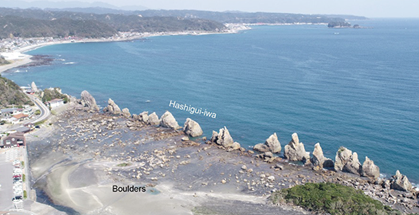
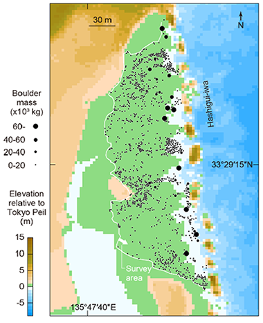
Hashigui-iwa in Kushimoto Town, Wakayama Prefecture. On the landward side of Hashigui-iwa, numerous large boulders are distributed (upper). We conducted field surveys of the surrounding area to measure the locations and sizes of these boulders (lower). Numerical simulations revealed that some boulders did not move during the tsunami generated by the 1707 Hoei earthquake, which is considered the largest historical event along the Nankai Trough. This finding indicates that larger tsunami(s) than the 1707 event struck this site and transported the boulders. Photograph and figure are published in Namegaya et al. (2022 Tectonophysics).
- Yuki Sawai (Leader, Group)
- Yuichi Namegaya (Chief Senior Researcher)
- Dan Matsumoto (Senior Researcher)
- Koichiro Tanigawa (Senior Researcher)
- Kei Ioki (Senior Researcher)
- Yumi Shimada (Researcher)
- Yu Honda (Research Assistant)
- Ryoko Koyama (Technical Staff)
I am trying to advance understanding of subduction zone earthquakes by studying relative sea-level changes and tsunami deposits. I began these studies with my doctoral dissertation on estuarine stratigraphy and diatom micropaleontology in Hokkaido. I applied that experience to Tohoku and found geologic evidence of the Jogan tsunami in Sendai region. Elsewhere on the Pacific Rim, I have contributed to findings on the earthquake and tsunami hazards of southern Chile and the northwestern US and Canada.
I aim to clarify historical descriptions and conduct field surveys to investigate the scale of tsunamis, the amount of crustal deformation, and the extent of damage caused by tsunamis that occurred prior to the Meiji era. Based on these data and geological records, I work to estimate earthquake magnitudes using methods such as tsunami inundation simulations. My studies primarily focus on subduction-zone earthquakes around Japan, including those along the Sagami Trough.
I am engaged in research to identify ancient tsunami deposits preserved in coastal lowland strata from a sedimentological perspective, such as sedimentary structures and grain size, to reconstruct the history and scale of past tsunamis. I primarily conduct fieldwork in Wakayama Prefecture and western Shikoku along the Nankai Trough. Additionally, as modern analogues for paleotsunami sediment research, I also investigate recent tsunami deposits, such as those from the 2004 Indian Ocean tsunami and the 2011 Tohoku offshore earthquake tsunami.
My research focuses on understanding the histories of megathrust earthquakes and associated tsunamis based on geological paleoseismic evidence. I have studied coastal lowlands along the Pacific coast of Japan (e.g., Hokkaido, Aomori, and Kochi) and Canada using fossil diatom and sedimentological analyses. My research interests extend to reconstructing the long-term sea-level changes and related coastal environmental changes from the latest Pleistocene to the Holocene.
To clarify how earthquakes and tsunamis occurred, I compute tsunami inundation using geological records such as tsunami deposits and historical records such as ancient documents. I mainly study earthquakes that occur in the Kuril Trench and Hyuga-nada.
My research aims to identify sources of event deposits and to reconstruct coastal uplift and subsidence, using fossil diatom assemblages. I mainly focus on coastal lowlands along the Nankai Trough.
My research focus is the identification of event deposits and the reconstruction of paleoenvironments using fossil diatom assemblages. My primary study area is Masuda City, Shimane Prefecture.
I am responsible for supporting research on tsunami deposits, specializing in grain-size analysis.