Research Group
Quaternary Basin Research Group *
Leader, Group, Tomonori NAYA
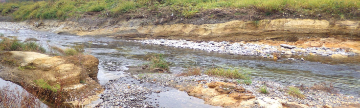
Quaternary Basin Research Group conducts surveys and research to provide highly accurate geological information on the Quaternary strata distributed in and around the plains. We are also involved in the development of various geological maps and geological maps of urban areas in collaboration with the Coastal Area Project and the 3D Geological Map Project.
Stratigraphy and Tectonics Research Group *
Leader, Group, Hidetoshi HARA
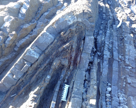
Stratigraphy and Tectonics Research Group is a core group of the "Land Geologic Map Project". We produce and publish 1:50,000 and 1:200,000 scale geologic maps of the Japanese Islands. In order to understand geology of Japanese Island Arc, we conduct basic researches of stratigraphy and tectonics in accretionary complex, fore-arc basin, intra-arc basin, back-arc basin.
Orogenic Processes Research Group *
Leader, Group, Takashi KUDO
As one of the core groups of the Terrestrial Geologic Map Project, we produce 1:50,000 and 1:200,000 scale geologic maps of the Japanese Islands. We also conduct basic research to elucidate the formation and development of the island arc crust using stratigraphic, petrological, volcanological, geochemical, and structural geological techniques to understand the history of geological structure, regional tectonics, magma processes, crustal thermal history, and volcanic activity.
Integrated Geo-information Research Group
Leader, Group, Takayuki UCHINO
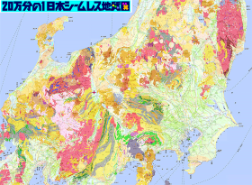
Integrated Geo-information Research Group updates and enhances the functionality of the 1:200,000 Japan Seamless Geological Map (ver. 2), create 1:200,000 and 1:50,000 geological map widths, create landslide risk assessment maps, as well as engage in updating JIS fir geological map and international standardization of file formats.
Geoinformatics Research Group *
Leader, Group, Susumu NONOGAKI
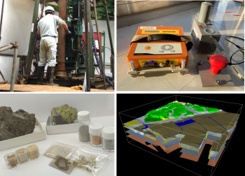
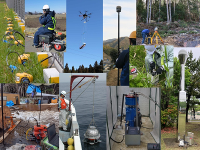
Geoinformatics Research Group researches techniques for acquiring and analyzing fundamental geological information from field surveys and laboratory analyses. Our field surveys include geological reconnaissance, borehole surveys, and microtremor observations. We also focus on integrating and advancing geological information from various fields so that we can contribute to mitigating geological hazards. One of the representative products includes the 3D Urban Geological Maps.
Remote Sensing Research Group
Leader, Group, Satoru YAMAMOTO
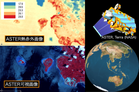
The Remote Sensing Research Group provides high-quality open free satellite remote-sensing data through research on calibration and validation of remote-sensing data, data archiving, and sensor development. The group also conducts research on disaster prevention, the Earth environment, and thematic mapping using various remote-sensing data including ASTER and HISUI, as well as earth and planetary sciences to promote the utilization of satellite remote-sensing data.
Marine Geology Research Group
Leader, Group, Takahiko INOUE
Paleogeodynamics Research Group *
Leader, Group, Takuya ITAKI
Marine Geo-Environment Research Group *
Leader, Group, Akira IGUCHI
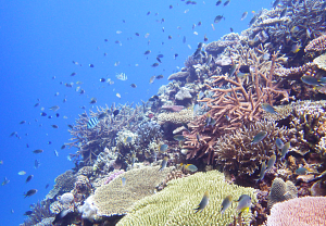
To elucidate geological problems related to global environmental issues that are feared to become more serious in the future, i.e., ocean warming, sea-level rise, ocean acidification, and ocean deoxygenation, and to promote research to reconstruct their past changes. For the exploration and development of marine energy and mineral resources, we will plan environmental baseline studies using marine geological, physical, molecular ecological, and biogeochemical methods, with a particular focus on environmental impact assessment.
Tectonics and Resources Research Group *
Leader, Group, Mikiya YAMASHITA
In order to understand the amount of seafloor mineral resources in Japan, we conduct bathymetric and marine geological surveys in cooperation with other research groups and divisions. We conduct petrological and geochemical studies on sediments and basement rocks obtained from these surveys to narrow down potential area of seafloor mineral resources.
Geochemistry Research Group
Leader, Group, Atsuko AMANO
The Geochemistry Research Group produces geochemical reference materials that serve as standards for the analysis of all geological samples and geochemical maps that help to elucidate the behavior of elements on the surface of the earth's crust. The group also enhance the database of existing standard samples and geochemical maps.
Geophysics Group *
Senior Geophysicist, Group, Ayumu MIYAKAWA
The Geophysics Group promotes research to understand various physical phenomena occurring on Earth and to predict changes from the past to the future, in addition to elucidating the present state of the planet. Specifically, the group creates geophysical maps and databases, develops and improves techniques for exploring, analyzing, and interpreting subsurface and crustal structures, and devises three-dimensional subsurface modeling methods and simulation techniques based on geophysical information.
* Japanese Site only
- Top page
- Organization
- Project
- Group
- Quaternary Basin Research Group *
- Stratigraphy and Tectonics Research Group *
- Orogenic Processes Research Group *
- Integrated Geo-information Research Group
- Geoinformatics Research Group *
- Remote Sensing Research Group
- Marine Geology Research Group
- Paleogeodynamics Research Group *
- Marine Geo-Environment Research Group *
- Tectonics and Resources Research Group *
- Geochemistry Research Group
- Geophysics Group *
- Database
* Japanese Site only