Geo-environmental Risk Research Group
Japanese


Geochemical and Risk Assessment Map of Subsurface Soils
Soil has strong impacts on agriculture and environment. Human exposure to toxic substances included in soils may occur due to inhalation of flying soil particles, and ingestion of groundwater and foods. Therefore, establishment of quantitative information about both geochemical properties and potential risks of subsurface soils has many practical implications, such as land use planning, distinguishing naturally occurring or artificial contaminations, and risk communication etc.
Leaching and total concentrations of soil samples taken from a region (such as a prefecture) are investigated and distributions of toxic heavy metals such as Lead (Pb), Arsenic (As) and Cadmium (Cd) are mapped in advance across the survived region. Quantitative risk assessment is then performed by considering the life-style (potential exposure pathways) in the same region and mapped for individual substances of concern. Risk level is indicated by the ratio of daily intake to ADI (Acceptable Daily Intake) or RfD (Reference Dose) suggested by WHO. The figures shown below illustrate the maps of leaching concentration (upper), total concentration (middle) and potential risk (bottom) across Tottori Prefecture as an example.
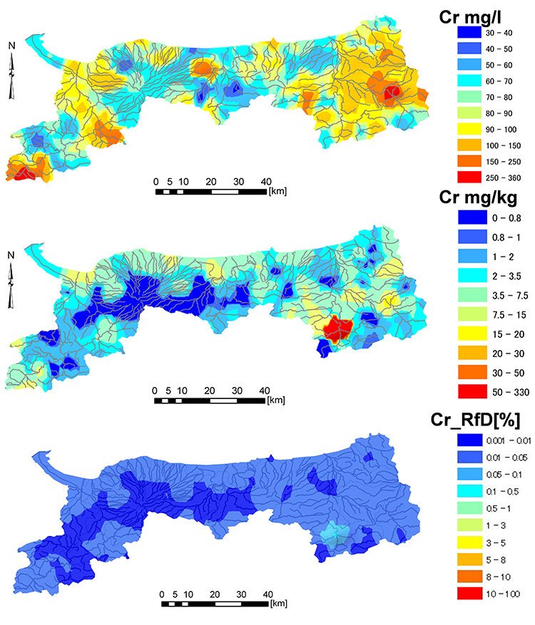
Leaching concentration, total concentration and potential
risk of Cr cross Tottori Prefecture (an example)
Currently, the maps for Miyagi, Tottori, Toyama, Ibaraki and Kochi prefectures have been published.
-
Geological Survey of Japan >Catalogue of Geological Maps >Environment >Other Maps
- CD-ROM E- 3 Geochemical and risk assessment map of subsurface soils of Miyagi Prefecture
- CD-ROM E- 4 Geochemical and risk assessment map of subsurface soils of Tottori Prefecture
- CD-ROM E- 5 Geochemical and risk assessment map of subsurface soils of Toyama Prefecture
- CD-ROM E- 6 Geochemical and risk assessment map of subsurface soils of Ibaraki Prefecture
The maps are available at Geological Survey of Japan through the following link site: Geological Survey of Japan >Catalogue of Geological Maps >Purchase Guide
The map of Kochi prefecture is open on Web, and the KMZ file which can be displayed on Google Earth TM is available: from the website of Geological Survey of Japan
Plan and survey for publishing a national-wide map has been started and will be finished within next several years.