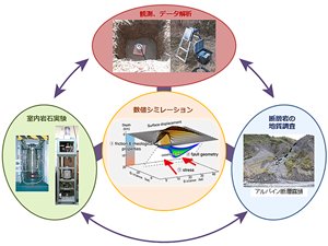
地震テクトニクス研究グループでは,地震観測・解析,過去深部にあった断層帯の地質調査,室内岩石実験,数値シミュレーション,などの研究を有機的に連携させて,地震が発生する場や発生にいたるプロセスを解明する研究に取り組んでいます.
関東地域における地震テクトニックマップを公表し,現在は,中国地域における地震テクトニックマップの作成と,今後いち早く全国整備を終えるために,地震解析の加速化の研究を行っています.また,脆性から塑性に至る断層変形プロセスの解明,プレート境界地震と内陸地震の相互作用を考慮したサイクルシミュレーターの開発にも取り組んでいます.
これらの研究を通して,物理モデルに基づいた地震の規模と発生時期の予測技術の確立を目指しています.

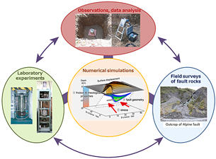
Our group aims to elucidate the physical and mechanical properties of the seismogenic zone, and the generation processes of large earthquakes, by linking seismological observations and data analysis, geological studies of exhumed faults, laboratory experiments, and numerical modelings.
We have published the seismotectonic map of the Kanto region, and are currently constructing a seismotectonic map of the Chugoku region (SW Japan) based on detailed knowledge of local stress fields. We also aim to accelerate seismic data processing in order to complete seismotectonic maps for all regions of Japan. Furthermore, we are studying the deformation processes operating within fault rocks under conditions spanning the brittle to ductile regimes, and we are developing simulation techniques by integrating the interaction between subduction-zone - and inland earthquakes.
Our studies provide a basis for improving accuracies of long-term forecasting and evaluation of the magnitudes of future earthquakes.