1. Introduction
For more than a decade, the National Institute of Advanced Industrial Science and Technology (AIST) has been conducting surveys and research on tsunami deposits to elucidate giant tsunamis of the past. Tsunami deposits refer to sand layers left within geological formation in coastal lowlands, which are natural records of giant tsunamis of the past. By using them, we have discovered that a heretofore unknown giant tsunami hit Pacific coastal areas of eastern Hokkaido in the 17th century. Further, we have built on this work in Hokkaido to conduct surveys of tsunami deposits along the Pacific coast of the Tohoku District, southwest Japan etc. This led us to find out that, in the Tohoku District, giant tsunamis have hit the Sendai Plain, the Ishinomaki Plain and Fukushima Prefecture's coastal plains at intervals of about 500 years, and to publish this finding.
2. Records of giant tsunamis of the past
While giant tsunamis, like the latest one, may occur anywhere along the Pacific coast of Japan, the scales and occurrence times of tsunamis of the past are known from historical records and geological formation records. Along the Pacific coast of southwest Japan, much is known about the occurrence times of Nankai and Tokai earthquakes of the past and the scales of tsunamis caused by them. This is because, in southwest Japan, giant earthquakes recur at relatively short intervals and because historical documents are abundant. The largest documented earthquake is the 1707 Hoei event, which is thought to have ruptured the whole length from the Suruga Bay to off the coast of Shikoku.
By contrast, giant earthquakes recur at longer intervals and fewer historical records are available for the Tohoku District and Hokkaido, and so the recurrence intervals and scales of giant tsunamis of the past cannot be estimated on the basis of historical records alone. In such localities, tsunami deposits, which are natural records of giant tsunamis, serve as the only clue to evaluate the recurrence intervals and scales of tsunamis of the past.
Even along the Pacific coast of southwest Japan, historical records are available only as far back as the 648 Hakuho earthquake, and no earlier records exist. Also, historical records are incomplete for earthquakes that occurred before the Edo period (17-19c). It is therefore essential to conduct surveys and research on tsunami deposits, in southwest Japan as well, to investigate the risk of giant tsunamis that are unknown in history.
3. Tsunami deposits
Tsunami deposits are included in geological formations beneath plains that develop along coastlines. Coastal plains have sand dunes developing along the coastline, slightly elevated topographically, and have flat lowlands on the landward side of them, which form wetlands or tidal flats if they are left in a pristine state. Pristine environments survive along the Pacific coast of eastern Hokkaido, including the well-known Kiritappu Wetland. Along the Pacific coast of Honshu, by contrast, most of what used to be wetlands have been turned into rice paddies.
In wetlands, where water flows slowly, little sand is deposited, whereas decayed vegetation matter (peat) and mud are deposited slowly. However, a giant tsunami, which flows in across dunes from the coastline, erodes sand from beaches and dunes, which it carries over to the wetlands to form extensive sand layers. When the tsunami is gone, the wetlands return to their original state where peat and mud are deposited. Tsunami deposits refer to the sand layers that are left caught between peat or mud layers as a consequence. In wetlands, not only tsunamis but also large-scale floods may carry sand, but analysis of fossil diatoms etc. in sand allows one to tell whether the sand was carried by sea or by land. Inundation areas of tsunamis of the past can be reproduced by tracing these sand layers carefully and elucidating their spatial extent and dates.
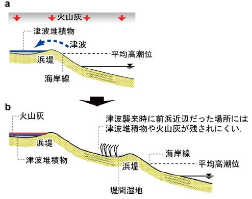
Schematic illustration of beach ridges. Beach ridge progression (from a to b) and how it relates to the deposition and preservation of tsunami deposits and volcanic ashes. (Shishikura et al., 2010, AFERC News, No. 16, in Japanese).
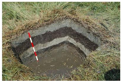
Example of tsunami deposits observed in an excavated pit.
Tsunami deposits left by giant tsunamis (light gray) and peat layers (dark brown) can be observed.
4. Future challenges
However, the magnitude of the earthquake that caused a giant tsunami in the past (the 869 Jogan earthquake) was estimated at M 8.4 on the basis of tsunami deposit surveys in Miyagi and Fukushima Prefectures, which is substantially smaller than that of the latest Tohoku event. This is presumably partly because tsunami deposit surveys were yet to be done along the Sanriku and Ibaraki Prefecture coasts, and also partly because of insufficient consideration of the fact that tsunami inundation areas are broader than the tsunami deposit distribution areas. One should presume that the actual scale of the tsunami was larger than that reproducible from tsunami deposits. The latest Tohoku earthquake has highlighted the necessity to improve methods to evaluate actual scales of tsunamis with high precision.
There thus remain challenges to be overcome before scales of tsunamis can be estimated accurately from surveys and research on tsunami deposits, but one should bear in mind that the very presence of tsunami deposits themselves is a grave warning issued by nature.
