Origin time: Around 14:46, 11 March 2011
Hypocenter: Off the coast of Miyagi Prefecture, 38°02'N, 143°09'E, about 10 km in depth
Magnitude: 9.0 (moment magnitude)
 |
|
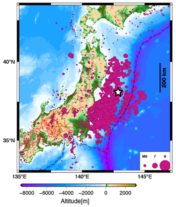
Distribution of aftershocks following the 11 March 2011 mainshock (as of 27 March). The hypocenter information is due to the JMA integrated catalog.
|
|
This earthquake occurred on a plate boundary where the Pacific plate meets the North American plate (or the Okhotsk plate) on which northeastern Japan is located. According to analysis by the National Research Institute for Earth Science and Disaster Prevention (NIED), it is inferred that plate boundary fault rupture began at the hypocenter off the coast of Miyagi Prefecture and propagated as far as off the coast of Iwate Prefecture to the north and off the coast of Ibaraki Prefecture to the south. It is estimated that this earthquake was of a multi-segment type, consisting of multiple events occurring successively. GPS observation by the Geospatial Information Authority of Japan (GSI) indicates that the entire body of eastern Japan moved to the east as if being pulled toward the earthquake source area. Crustal deformation was the largest along the southern part of the Sanriku coast, with Oshika Peninsula moving 5.3 m to the ESE and subsiding 1.2 m. Broad-scale subsidence occurred in coastal areas, and is presenting great obstacles to recovery efforts.
The spatial extent of fault rupture and the amount of slip during the earthquake have been evaluated using records of seismometers, crustal deformation based on GPS observation, tsunami waveforms at different sites etc. The extent of the fault rupture area and the amount of slip vary somewhat according to the data on which they are based, but it is inferred that a fault extending roughly 400 km in the north-south direction and roughly 200 km wide slipped by about 15-20 m on average and nearly 30 m at the maximum.
This massive fault slip generated crustal deformation on the order of several meters on the sea bottom, causing a giant tsunami. The waves are estimated to have reached heights of 15-20 m inside inlets along the ria coast in southern Sanriku, the most severely hit by the tsunami. The wave heights are also estimated at around 10 m from the Ishinomaki Plain to the Sendai Plain in Miyagi Prefecture, and around 14 m near the nuclear power plants in Fukushima Prefecture. The tsunami also caused great damages to coastal areas from Hokkaido to Chiba Prefecture.
Earthquake source fault models have been published by the following research institutions:
Earthquake Research Institute, the University of Tokyo
National Research Institute for Earth Science and Disaster Prevention (NIED)
Geospatial Information Authority of Japan (GSI)
Building Research Institute
University of Tsukuba
A list of research institutions' information Websites on this earthquake is given on the Headquarters for Earthquake Research Promotion Website.
