AIST
AFERC
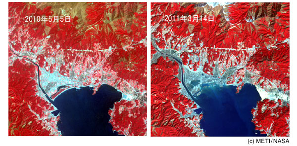
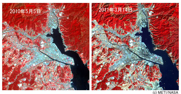
Satellite image information

The Geological Survey of Japan (GSJ) is conducting, jointly with the Ministry of Economy, Trade and Industry (METI) and ERSDAC, analysis of satellite images using ASTER sensors.
Below are images acquired by ASTER sensors (sensors developed by METI: http://www.gds.aster.ersdac.or.jp/) mounted on artificial satellites.

Images of Rikuzen-Takata and Kesennuma

Red, green and blue are assigned to ASTER bands 3, 2 and 1, respectively. Vegetation is shown in red.

Rikuzen-TakataF Tsunami has reached the innermost parts of the bay and has changed the coastline geometry.
Rikuzen-Takata: Tsunami has reached the innermost parts of the bay and has changed the coastline geometry.
Erosion is most conspicuous near the Takata Matsubara (Takata pine forest), where water has not receded more than two days after the earthquake.
This image covers an area about 9.5 km per side.


KesennumaF Debris of buildings etc. damaged by tsunami, as well as sand and mud carried from the ocean, have changed the coloring of the town area.
Kesennuma: Debris of buildings etc. damaged by tsunami, as well as sand and mud carried from the ocean, have changed the coloring of the town area.
This image covers an area about 6 km per side.

Send your comments on this Website to the following email address:
Research Planning Office, Geological Survey and Applied Geoscience:

Link to this page is free.
Please refer explicitly to our URL when you cite figures, text etc. from this page.

Active Fault and Earthquake Research Center
National Institute of Advanced Industrial Science and Technology (AIST)
Tsukuba Central 7, 1-1-1 Higashi, Tsukuba, Ibaraki 305-8567, Japan
Copyright © 2011 Active Fault and Earthquake Research Center. All Rights Reserved.