Level-1A data product consists of the image data, the radiometric
coefficients, the geometric correction coefficients and the auxiliary
data. The Level-1B data products will be generated by using these
data for the requested map projection and resampling method.
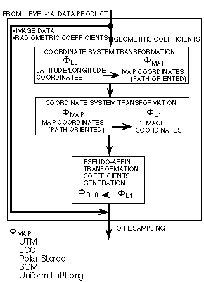
Figure 3-1 shows the pseudo-affine coefficients generation
algorithm flow for map projections such as UTM, LCC, SOM, Polar
Stereo and Uniform Lat/Long. The coordinate transformation from
latitude/longitude to the selected map projection coordinates is
followed by the coordinate transformation to Level-1 coordinates
according to the pixel size units of each band. The path-oriented
coordinates are used rather than the map-oriented coordinates in
order to keep the image quality as close to the Level-0 data as
possible. The pixel sizes of Level-1 are 15 m for VNIR bands, 30 m
for SWIR bands and 90 m for TIR bands on the standard lines for each
map projection regardless of real pixel sizes which depends slightly
on the spacecraft altitude and pointing angle.
A set of the pseudo-affine transformation coefficients which
consists of eight coefficients are generated for each block of
Level-1 coordinates by using the relation from the Level-0B to the
Level-1 coordinates according to the well-established usual
procedure. The size of the block is the same as that of Level-0
coordinates.

Figure 3-1 Map Projection
|